Pollution
What is air quality
‘Air quality’ describes the cleanliness of the air we breathe, and ‘poor air quality’ means that the air is polluted with gases and particles which are harmful to our health.
Air pollution and health
Long-term exposure to air pollution is estimated to cause as many as 4000 premature deaths each year. Air pollution can affect everyone's health at any stage in our lives, but children and young people, older people, and people with existing lung or heart conditions are more vulnerable to the health effects of air pollution.
(Dajnak D et al, London Health Burden of Current Air Pollution and Future Health Benefits of Mayoral Air Quality Policies, Environmental Research Group: Imperial College London; 2019, p1-72.)
Measuring and improving air quality
The Ricardo Air Quality England Network reports pollution levels recorded during the day at the two Redbridge automatic monitoring stations. Summary reports are also available to view for each monitoring site.
We measure air quality in two different ways: with small ‘diffusion tubes’ which measure NO2 levels, and with automatic electronic sensors at monitoring stations.
There are 2 monitoring stations in Redbridge:
- Gardner Close, Wanstead
- Ley Street Depot, Ilford
These take hourly readings of a range of air pollutants including nitrogen oxides, particulates and ozone.
In December 2022, there were 26 diffusion tube monitoring sites across the borough; the tubes are tested in a laboratory each month, to provide NO2 concentrations.
Our monitoring data is reported to the Greater London Authority each year in Annual Status Reports.
Water quality
Water Pollution and Drainage Misconnections
What is a misconnection?
A misconnection is where drainage from your home has been connected to the wrong part of the sewer or surface water network.
Types of misconnection:
- Foul water drainage from toilets, sinks and washing machines etc. could be connected to the surface water (rain) system. This can pollute the local environment as these systems discharge to nearby streams, rivers, or the sea.
- Surface water drainage (from rain) could be connected to the foul water sewer system. This can overload the system causing flooding from manholes or premature discharges from storm overflows.
How do misconnections happen?
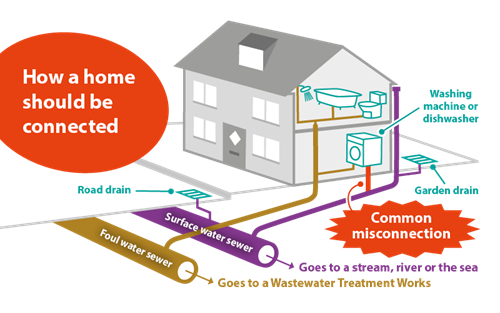
Misconnections can occur when a property is first built or when home renovation work is done which require changes to, or additional, plumbing. The diagram shows how a home should be connected to the correct drain and sewer. The most common type of misconnection are appliances (washing machines and dishwashers) and sinks to outside surface water drains, rather than to the foul water sewer.
Who is responsible for correcting a misconnection?
Since October 2011 water companies have taken over the ownership of private sewers. This means you are responsible for the drains from your property up to the point they combine with drains from a neighbouring property. After this point they are the responsibility of your water company.
- If you own the property, you are responsible, even if the misconnection was made by a previous owner. The Building Act 1984 can be used to deal with unsatisfactory provision for drainage and appliances which are harmful to health or a nuisance. The Council can serve legal notices on the person responsible to ensure that satisfactory drainage provisions are achieved.
- If you rent the property, you should contact the landlord who is responsible for putting it right. This may be the local council, housing association or a private landlord.
How can I avoid misconnecting?
Checklist to ask your builder or plumber:
- Are you installing a new toilet, sink or appliances? (Foul/waste sewer connection)
- Are you connecting new surface drainage? (Surface water system)
- Do you know the location of the sewer you want to connect to and where you want to connect to it? Have you looked for nearby manholes or at sewer records from London Borough of Redbridge and Thames Water for an indication of where you may connect?
- Have you double checked you have the correct sewer? (Foul/surface water sewer)
Further information
If you believe you have a misconnection, need any further help, or have any questions, contact Thames Water customer service line on 0800 316 9800 or visit the Thames Water website, for misconnected pipes, on their home improvements page.
Site search enquiry
How we deal with land containing contaminants
Land with contaminants can be dealt with in two ways; either through the planning process during the redevelopment of a site or through the identification of 'contaminated land' under Part IIA of the Environmental Protection Act 1990